Science
Related: About this forumCoronavirus: Archaeologists uncover dozens of historic sites -- while working from home
Technology allows volunteers to map previously unknown roads, settlements and farms
Jane Dalton @JournoJane
3 hours ago
Archaeology volunteers staying at home during the coronavirus lockdown have discovered dozens of previously unrecorded Roman, prehistoric and Medieval sites.
The team found parts of two Roman roads, around 30 prehistoric or Roman large embanked settlement enclosures, and 20 prehistoric burial mounds.
They also pinpointed the remains of hundreds of Medieval farms, field systems and quarries.
And the project leaders say they expect to make many more discoveries in the coming weeks.
The Devon-based team are analysing images derived from Lidar (light detection and ranging) data, a technique for measuring distances by illuminating a target with laser light and measuring the reflection with a sensor.
More:
https://www.independent.co.uk/independentpremium/coronavirus-lockdown-archaeologist-discover-roman-sites-roads-farms-devon-a9511196.html
 = new reply since forum marked as read
Highlight:
NoneDon't highlight anything
5 newestHighlight 5 most recent replies
= new reply since forum marked as read
Highlight:
NoneDon't highlight anything
5 newestHighlight 5 most recent replies

niyad
(113,636 posts)
napi21
(45,806 posts)I understand a bit about archaeology ad you don't find things like that with your computer in your livingoom.

radical noodle
(8,016 posts)Lidar technology is used during aerial surveys to produce highly detailed topographical maps.
Modern vegetation and buildings can be removed from the picture, allowing archaeologists to look at the shape of the land surface to find the remains of ancient earthworks.
The data uncovered is now being examined and cross-referenced with records of known archaeology and historic maps, so the total of new discoveries constantly changes.
So it would seem that the aerial photographs can be accessed and studied with their computers. At least that's the way it seems to me.

Judi Lynn
(160,651 posts)Experts: Teen's 'Discovery' of Maya City is a Very Western Mistake
Why modern astronomical maps may not lead us to ancient sites.
3 MINUTE READ
BY KRISTIN ROMEY
PUBLISHED MAY 11, 2016Updated: May 18, 2016 (see below)
For gee-whiz value, the announcement has been hard to beat: A Canadian teenager discovers a lost Maya city without even stepping foot in the Central American jungle.
Unfortunately, this "discovery" appears to be the well-intentioned, albeit faulty, result of modern Western education colliding with an ancient civilization that saw the world in a very different way.
According to the original news report, 15-year-old William Gadoury correlated more than 20 Maya constellations against a map of known Maya cities. The cities lined up perfectly with the star map, with the exception of a "missing" settlement in a constellation that includes the sites of Calakmul and El Mirador.
Gadoury pinpointed the location of the potential site in Campeche, Mexico by using its corresponding star. An analysis of satellite imagery from the location, performed by Armand LaRocque, an honorary research associate at the University of New Brunswick, allegedly revealed a pyramid and dozens of buildings.
More:
https://www.nationalgeographic.com/news/2016/05/20160511-Maya-Lost-City-Canadian-Teen-Discover-Constellations-Archaeology-Satellite-Stars-Gadoury/
Here's a more recent find:
Sprawling Maya network discovered under Guatemala jungle
2 February 2018
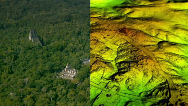
WILD BLUE MEDIA/CHANNEL 4
Image caption
The Maya city of Tikal was found to be just a fraction of an immense hidden metropolis
Researchers have found more than 60,000 hidden Maya ruins in Guatemala in a major archaeological breakthrough.
Laser technology was used to survey digitally beneath the forest canopy, revealing houses, palaces, elevated highways, and defensive fortifications.
The landscape, near already-known Maya cities, is thought to have been home to millions more people than other research had previously suggested.
The researchers mapped over 810 square miles (2,100 sq km) in northern Peten.
Archaeologists believe the cutting-edge technology will change the way the world will see the Maya civilisation.
"I think this is one of the greatest advances in over 150 years of Maya archaeology," said Stephen Houston, Professor of Archaeology and Anthropology at Brown University.
More:
https://www.bbc.com/news/world-latin-america-42916261
~ ~ ~
A woman discovered structures under the desert sand in Africa:

The streets have no name. Satellite imagery reveals a maze of streets and buildings at the ancient Egyptian city of Tanis. DIGITALGLOBE
Satellite Imagery Uncovers Up to 17 Lost Egyptian Pyramids
By Heather PringleMay. 27, 2011 , 4:56 PM
When Napoleon Bonaparte invaded Egypt in 1798, he brought more than 150 scientists and scholars along with his massive army. The scholars fanned out across Egypt, describing the country’s natural and cultural history, mapping archaeological sites from Alexandria to Aswan, and bringing places such as the Valley of the Kings to the attention of the scientific world for the first time. This week, an American research team announced that it has succeeded in a high-tech follow-on to Bonaparte’s grand survey. By analyzing high-resolution satellite imagery covering all of Egypt, researchers have reportedly discovered up to 17 lost pyramids, nearly 3000 ancient settlements, and 1000 tombs.
The effort was led by archaeologist Sarah Parcak of the University of Alabama, Birmingham. The team’s work will be highlighted in a BBC documentary airing Monday in the United Kingdom and later on the Discovery Channel in the United States.
The findings are groundbreaking, says Egyptologist Willeke Wendrich of the University of California, Los Angeles, who has followed closely the team’s as-yet unpublished work. “It gives us the opportunity to get at the settlement of ancient Egypt without digging even a centimeter,” she says.
In the wake of the finds, the Egyptian government reached an agreement this week to work with Parcak and other American researchers to develop a nationwide satellite imagery project to monitor archaeological sites from space and protect them from looting and illegal house construction and other encroachments. “We are going to be teaching young Egyptians how to look at the satellite data and analyze it so they can keep an eye on these sites,” Parcak says. She and her colleagues plan to raise funds privately to support the effort.
Parcak began her study 11 years ago, searching for traces of ancient village walls buried under Egypt’s fields and desert sands. Obtaining images from both NASA and QuickBird satellites, she combined and analyzed data from the visible imagery as well as the infrared and thermal parts of the light spectrum. Through trial and error, she discovered that the most informative images were taken during the relatively wet weeks of late winter. During this period, buried mud-brick walls absorbed more moisture than usual, producing a subtle chemical signature in the overlying soil that showed up in high-resolution, infrared satellite images. These places became “our hot spots, the places that we could end up exploring on foot,” Parcak says.
More:
https://www.sciencemag.org/news/2011/05/satellite-imagery-uncovers-17-lost-egyptian-pyramids
~ ~ ~
Wildly valuable tools have emerged which have changed the way things happen now. It is astonishing!

woodsprite
(11,932 posts)Preliminary research on Zooniverse (crowd sourced research app). Really cool!