Welcome to DU!
The truly grassroots left-of-center political community where regular people, not algorithms, drive the discussions and set the standards.
Join the community:
Create a free account
Support DU (and get rid of ads!):
Become a Star Member
Latest Breaking News
General Discussion
The DU Lounge
All Forums
Issue Forums
Culture Forums
Alliance Forums
Region Forums
Support Forums
Help & Search
General Discussion
In reply to the discussion: Leaked New York Times Gaza Memo Tells Journalists to Avoid Words "Genocide" "Ethnic Cleansing" and "Occupied Territory" [View all]
Celerity
(43,454 posts)18. NYT covertly pushing gaslighting
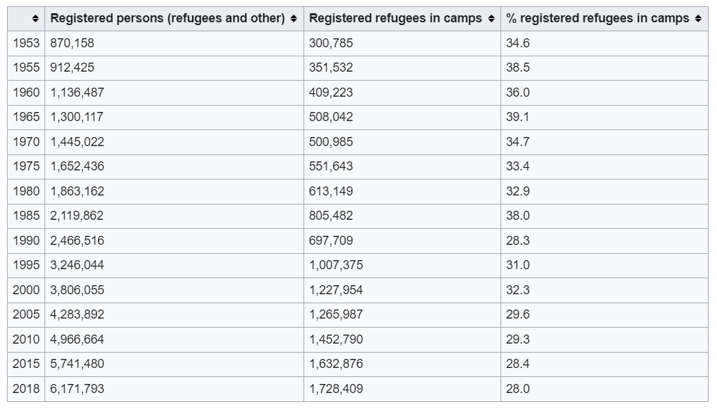
The memo also instructs reporters not to use the word Palestine “except in very rare cases” and to steer clear of the term “refugee camps” to describe areas of Gaza historically settled by displaced Palestinians expelled from other parts of Palestine during previous Israeli–Arab wars. The areas are recognized by the United Nations as refugee camps and house hundreds of thousands of registered refugees.
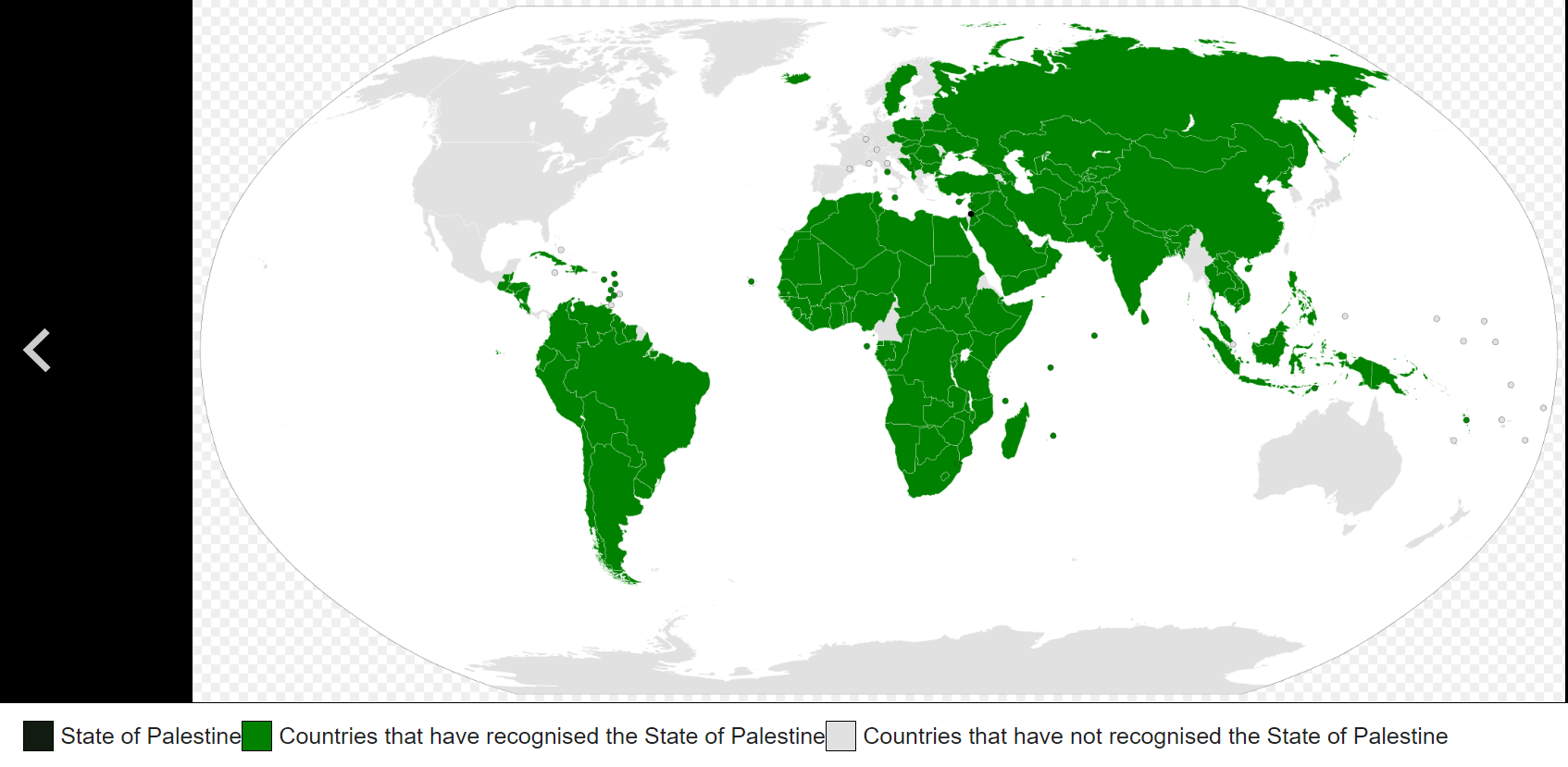
State of Palestine
https://en.wikipedia.org/wiki/State_of_Palestine
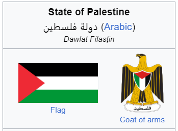
Palestine, officially known as the State of Palestine, is a country in the Levant region of West Asia. It is officially recognized as a state by the United Nations and numerous countries. Palestine shares borders with Israel to the west and north, Jordan to the east, and Egypt to the southwest. The state comprises the West Bank, including East Jerusalem, and the Gaza Strip. The population of Palestine exceeds five million people, and covers an area of 6,020 square kilometres (2,320 sq mi). Jerusalem is its proclaimed capital and the official language is Arabic. The majority of Palestinians practice Islam, while Christianity also has a significant presence.
https://en.wikipedia.org/wiki/State_of_Palestine
Palestine, officially known as the State of Palestine, is a country in the Levant region of West Asia. It is officially recognized as a state by the United Nations and numerous countries. Palestine shares borders with Israel to the west and north, Jordan to the east, and Egypt to the southwest. The state comprises the West Bank, including East Jerusalem, and the Gaza Strip. The population of Palestine exceeds five million people, and covers an area of 6,020 square kilometres (2,320 sq mi). Jerusalem is its proclaimed capital and the official language is Arabic. The majority of Palestinians practice Islam, while Christianity also has a significant presence.
Palestinian refugee camps
https://en.wikipedia.org/wiki/Palestinian_refugee_camps
Camps are set up by the United Nations Relief and Works Agency (UNRWA) in Jordan, Lebanon, Syria, the West Bank and the Gaza Strip to accommodate Palestinian refugees registered with UNRWA, who fled or were expelled during the 1948 Palestinian expulsion and flight after the 1948 Arab–Israeli War or in the aftermath of the Six-Day War in 1967, and their patrilineal descendants. There are 68 Palestinian refugee camps, 58 official and 10 unofficial, ten of which were established after the Six-Day War while the others were established in 1948 to 1950s.
List of camps
The camps are divided between five regions:
Gaza Strip: The Gaza Strip has eight official and no unofficial refugee camps, and 1,221,110 registered refugees.
West Bank: The West Bank has 19 official and four unofficial refugee camps, and 741,409 registered refugees.
Syria: Syria has nine official refugee camps and three unofficial refugee camps, and 499,189 registered refugees.
Lebanon: There are 12 official refugee and no unofficial camps in Lebanon, and 448,599 registered refugees.
Jordan: There are 10 official and three unofficial refugee camps in Jordan, and 2,034,641 registered refugees.
Name Founded Location Status Coordinates Population Area (km2) Density (pop/km2) Comments
Yarmouk 1957 Syria Unofficial 33°28?27?N 36°18?11?E n.a. 2.1 n.a. Largely destroyed (was 160,000 population)
Rafah 1949 Gaza Strip UNRWA 31°16?58.87?N 34°15?11.52?E 125,304 n.a. n.a.
Baqa'a 1968 Jordan UNRWA 32°04?25?N 35°50?35?E 119,000 1.4 85,000
Jabalia 1948 Gaza Strip UNRWA 31°32?20.81?N 34°29?57.63?E 113,990 1.4 81,421
Khan Yunis 1949 Gaza Strip UNRWA 31°21?3?N 34°17?18?E 87,816 0.549 159,956
Al-Shati (Beach camp) 1948 Gaza Strip UNRWA 31°31?55.91?N 34°26?43.42?E 85,628 0.52 164,669
Nuseirat 1949 Gaza Strip UNRWA 31°26?51.56?N 34°23?34.35?E 80,194 n.a. n.a.
Ain al-Hilweh 1948 Lebanon UNRWA 33°32?37?N 35°22?41?E 59,660 0.3 198,867
Al-Wehdat refugee camp (Amman New Camp) 1955 Jordan UNRWA 31°55?35?N 35°56?18?E 57,000 0.48 118,750
Marka 1968 Jordan UNRWA 32°00?33?N 36°01?14?E 53,000 0.92 57,609
Jaramana 1948 Syria UNRWA 33°29?N 36°21?E 49,000 0.03 1,633,333
Latakia 1955–6 Syria Unofficial 35°30?28?N 35°47?45?E 47,400 0.22 215,455
Bureij 1949 Gaza Strip UNRWA 31°26?22.31?N 34°24?10.58?E 43,330 0.529 81,909
Rashidieh 1963 Lebanon UNRWA 33°14?12.12?N 35°13?5.16?E 34,584 0.25 138,336
Jabal el-Hussein 1952 Jordan UNRWA 31°57?52?N 35°54?23?E 32,000 0.42 76,190
Maghazi 1949 Gaza Strip UNRWA 31°25?16.89?N 34°23?07.35?E 31,329 0.6 52,215
Jerash 1968 Jordan UNRWA 32°16?20.21?N 35°53?29.03?E 29,000 0.75 38,667
Irbid 1951 Jordan UNRWA 32°33?0?N 35°51?0?E 28,000 0.24 116,667
Balata 1950 West Bank UNRWA 32°12?N 35°17?E 27,000 0.25 108,000
Deir al-Balah 1948 Gaza Strip UNRWA 31°25?33?N 34°20?26?E 25,569 0.16 159,806
Husn (Martyr Azmi el-Mufti camp) 1968 Jordan UNRWA 32°28?30?N 35°54?18?E 25,000 0.77 32,468
Burj el-Shemali 1955 Lebanon UNRWA 33°15?47?N 35°14?20?E 24,929 0.134 186,037
Shu'fat camp 1965 West Bank UNRWA 31°48?44?N 35°14?47?E 24,000 0.2 120,000
Qabr Essit 1967 Syria UNRWA 33°26?50?N 36°20?10?E 23,700 0.02 1,185,000
Tulkarm 1950 West Bank UNRWA 32°18?51?N 35°2?4?E 21,500 0.18 119,444
Beddawi 1955 Lebanon UNRWA 34°27?0.64?N 35°52?9.17?E 21,252 0.2 106,260
Zarqa 1949 Jordan UNRWA 32°05?N 36°06?E 20,000 0.18 111,111
Bourj el-Barajneh 1948 Lebanon UNRWA 33°50?54?N 35°30?12?E 19,539 0.104 187,875
Souf 1967 Jordan UNRWA 32°18?30?N 35°53?7.37?E 19,000 0.5 38,000
Askar 1950 West Bank UNRWA 32°13?11.51?N 35°17?50.77?E 18,500 0.119 155,462
Al-Nayrab 1948 Syria UNRWA 36°10?32?N 37°13?40?E 18,000 0.15 120,000
Dheisheh 1949 West Bank UNRWA 31°41?38.47?N 35°11?02.96?E 15,000 0.33 45,455
Kalandia 1949 West Bank UNRWA 33°19?55?N 36°19?56?E 14,800 0.42 35,238
Al-Hassan 1967 Jordan Unofficial 31°57?27?N 35°58?19?E 14,068 n.a. n.a.
Jenin 1953 West Bank UNRWA 32°27?41?N 35°17?11?E 14,000 0.42 33,333
Jalazone 1949 West Bank UNRWA 31°57?07.15?N 35°12?41.58?E 13,000 0.253 51,383
Al-Sabinah 1948 Syria UNRWA 33°26?2?N 36°17?8?E 13,000 0.03 433,333
Homs 1949 Syria UNRWA 34°42?30.29?N 36°42?26.62?E 13,000 0.15 86,667
Khan Danoun 1950 Syria UNRWA 33°19?55?N 36°19?56?E 12,650 0.03 421,667
El Buss 1948 Lebanon UNRWA 33°16?21?N 35°12?36?E 12,281 0.08 153,513
Al-Arroub 1950 West Bank UNRWA 31°37?23.18?N 35°08?12.19?E 12,000 0.24 50,000
Khan al-Shih 1949 Syria UNRWA 33°21?30?N 36°6?26?E 12,000 0.69 17,391
Shatila 1949 Lebanon UNRWA 33°51?46?N 35°29?54?E 10,849 0.04 271,225
Nur Shams 1952 West Bank UNRWA 32°19?07.36?N 35°03?31.63?E 10,500 0.21 50,000
Daraa 1950 Syria UNRWA 32°37?N 36°6?E 10,500 1.3 8,077 [57]
Fawwar 1949 West Bank UNRWA 31°28?46.45?N 35°03?52.93?E 9,500 0.27 35,185
Wavel 1948 Lebanon UNRWA 33°59?56.27?N 36°11?35.46?E 9,460 0.043 220,000
Hama 1950 Syria UNRWA 35°08?N 36°45?E 9,000 0.06 150,000 [60]
Aqabat Jaber 1948 West Bank UNRWA 31°50?17.00?N 35°26?30.20?E 8,600 1.67 5,150
Madaba camp 1956 Jordan Unofficial 31°42?41?N 35°47?15?E 8,597 n.a. n.a.
Far'a 1949 West Bank UNRWA 32°17?38.35?N 35°20?39.74?E 8,500 0.26 32,692
Talbieh Camp 1968 Jordan UNRWA 31°42?19?N 35°56?57?E 8,000 0.13 61,538
Ein Beit al-Ma' (Camp No. 1) 1950 West Bank UNRWA 32°13?48.91?N 35°14?58.42?E 7,500 0.045 166,667
Sokhna camp 1969 Jordan Unofficial 32°7?59?N 36°4?20?E 7,424 n.a. n.a. sometimes transliterated 'Sakhna' or 'Sukhna'
Am'ari 1949 West Bank UNRWA 31°53?38.60?N 35°12?41.52?E 7,000 0.096 72,917
Ein Al-Tal (also known as Handarat camp) 1962 Syria Unofficial 36°17?34.84?N 37°9?24.86?E n.a. 0.16 n.a. Largely destroyed (was 7,000 population)
Nahr al-Bared 1949 Lebanon UNRWA 34°30?47?N 35°57?40?E 5,857 0.198 29,581 Reconstructed, was 27,000 population
Mieh Mieh 1954 Lebanon UNRWA 33°32?30?N 35°23?29?E 5,747 0.054 106,426
Aida 1950 West Bank UNRWA 31°43?10.34?N 35°11?56.31?E 5,500 0.071 77,465
Dbayeh 1956 Lebanon UNRWA 33°54?N 35°34?E 4,591 0.084 54,655
Ein as-Sultan camp 1948 West Bank UNRWA 31°52?40.24?N 35°26?46.24?E 3,800 0.87 4,368
'Azza (Beit Jibrin) 1950 West Bank UNRWA 31°42?54.78?N 35°12?07.61?E 2,900 0.027 107,407
Deir 'Ammar Camp 1949 West Bank UNRWA 31°57?57.22?N 35°05?55.98?E 2,500 0.162 15,432
Qaddura camp 1948 West Bank Unofficial 31°54?3.32?N 35°12?21.18?E 1,558 n.a. n.a.
Mar Elias refugee camp 1952 Lebanon UNRWA 33°52?38?N 35°29?19?E 725 0.0054 134,259
Silwad Camp 1971 West Bank Unofficial 31°58?5?N 35°15?41?E 462 n.a. n.a.
Abu Shukheidim camp 1948 West Bank Unofficial n.a. n.a. n.a. Town of Abu Shukhaydam (sic) shows on maps as ~1mi SW of Birzeit
Birzeit camp (As-Saqaeif) 1948 West Bank Unofficial 31°58?12?N 35°12?01?E n.a. n.a. n.a.
Edit history
Please sign in to view edit histories.
18 replies
 = new reply since forum marked as read
Highlight:
NoneDon't highlight anything
5 newestHighlight 5 most recent replies
RecommendedHighlight replies with 5 or more recommendations
= new reply since forum marked as read
Highlight:
NoneDon't highlight anything
5 newestHighlight 5 most recent replies
RecommendedHighlight replies with 5 or more recommendations
= new reply since forum marked as read
Highlight:
NoneDon't highlight anything
5 newestHighlight 5 most recent replies
RecommendedHighlight replies with 5 or more recommendations
Leaked New York Times Gaza Memo Tells Journalists to Avoid Words "Genocide" "Ethnic Cleansing" and "Occupied Territory" [View all]
Mr. Sparkle
Apr 16
OP
Can they still use the word "apartheid in relation to Israel and the occupied lands?
John Farmer
Apr 16
#15
Not "Occupied Territories"? What are they going to use, "prime waterfront and riverside property", like Kushner?
muriel_volestrangler
Apr 17
#17