There was a small format problem. So here the second part of the investigation on Johnstown. Everybody who believes this is interesting should definteley read the first part of the investigation where especially the meeting of the Cambria County Local Emergency Planning Committee on 910 and other important issues surrounding Johnstown Airport are analyzed.
Whats happening at John P. Murtha Johnstown-Cambria County Airport on 911? In the days after 911 the following story is widely reported:
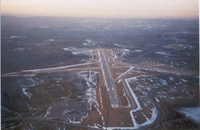
"Dennis Fritz, the air traffic manager, got a call from controllers in Cleveland warning the Johnstown airport -- which has no radar of its own
that a large aircraft was 20 miles south and had suddenly turned on a heading for Johnstown.
"It was an aircraft doing some unusual maneuvers at a low level, which is unusual for an aircraft that size," Fritz said last night.
http://www.post-gazette.com/headlines/20010912crashnat2p2.aspSupervisor Dennis Fritz and controller Thomas Hull picked up binoculars -- the tower has no radar -- and scanned the horizon to the south. The day was clear and, from the highest point in the area, they could spot radio towers in neighboring Somerset County.
A large plane would have stood out. "We didn't see a thing," Fritz said.
http://www.post-gazette.com/headlines/20011028flt93mainstoryp7.asp(This was) leading Fritz to believe that the plane was flying somewhere in the 2,800 foot high ridges in that part of the Allegheny front.
http://www.post-gazette.com/headlines/20010912crashnat2p2.asp"Dennis Fritz, director of the municipal airport in Johnstown, Pa., said the
FAA called him several times as the plane approached his city , and even warned him to evacuate the tower for fear the jet was going to plow into it.
(Washington Post, 9/13/01)
"When they (Cleveland) called back a minute later, it was 15 miles away. They suggested we evacuate the tower and the airport because they didn't know what was going to happen here. The aircraft was not communicating."
(Philadelphia Inquirer, 9/13/01)
On the first call from Cleveland, they said a 757 was heading in our direction at about 6,000 feet and descending , Fritz said. "They were repeatedly trying to raise the pilot on the radio, but there was no answer. " Within minutes, Fritz said, he began to move people from the tower but hesitated to abandon it completely because he felt the incoming plane might be in distress and need to make an emergency landing.
(Bergen Record, 9/14/01)
Ninety seconds later (after first call), Cleveland called back. The plane was now 15 miles south and heading directly for the Johnstown tower. "We suggest you evacuate," they told him.
Fritz ordered trainees and custodial staff out of the 85-foot tower. He and Hull stayed at their posts and scanned the south with binoculars. It occurred to Fritz that the plane must be flying below the level of the mountain ridges around them.
http://www.post-gazette.com/headlines/20011028flt93mainstoryp7.asp"Dennis Fritz, chief air traffic controller at the Johnstown airport, said he ordered the evacuation of nonessential employees at the tower and the airport around 10 a.m. Tuesday after being alerted to a large aircraft 20 miles to the south.
(Philadelphia Inquirer, 9/13/01)
Forty-five seconds after telling Fritz to evacuate the Johnstown tower, Cleveland Air Traffic Control phoned again.
"They said to disregard. The aircraft had turned to the south and they lost radar contact with him.
http://www.post-gazette.com/headlines/20011028flt93mainstoryp7.asp Then, somewhere within the air zone, about 15 miles south of Johnstown, the plane turned again toward the south." http://www.post-gazette.com/headlines/20010912crashnat2p2.aspThe plane crashed 16 miles south of Johnstown Airport.
(Bergen Record, 9/14/01)
This story of the third and last evacuation happening on the flight path of UA 93 (Cleveland and Pittsburgh, too) bears many questions.
All accounts that give a precise direction of the suspicious airplane heading towards Johnstown Airport agree that it was from the south.
(AP, 9/12/01 l)
(Philadelphia Inquirer, 9/13/01 b)
http://www.post-gazette.com/headlines/20011028flt93mainstoryp7.asphttp://www.post-gazette.com/headlines/20010912crashnat2p2.aspIt might be rather surprising that Johnstown Airport was ordered to evacuate as it certainly is not a target one could imagine the hijackers to be interested. So while the FAA ordered Pittsburgh control towers at 9:49 to evacuate
http://www.post-gazette.com/neigh_city/20010923city0923p5.asp no skyscraper in Pittsburgh was evacuated. But if the FAA wants to run no risk on 911 and evacuate all airports that could be touched then again its rather surprising that the advice was only given while UA 93 was only 20 miles away. Assuming a speed of 500 mph (it crashed with the official speed of 580 mph)
this means that Johnstown had only 2 ½ minutes to evacuate. Which certainly is not sufficient especially as Dennis Fritz doesnt decide immediately. So if the FAA wanted to run no risk when then wait so long?
But leaving this point aside and having a closer look at what happened at Johnstown Airport on 911 there are several very bizarre points that stand out:
Not only is the final crash site of UA 93 16 miles south of Johnstown Airport (so when first noticed as heading for Johnstown UA 93 is almost exactly at the very location it will later crash (being apparently lower than 2800 feet it is surprising that no eyewitness remarked this plane then))
but this direction is in contradiction to the official flight path of UA 93. If one has a look at the map and follows the official flight path the plane would be west or maximum southwest of Johnstown Airport. So, who is right?
There is one account that contradicts all the quoted statements that UA 93 was heading from the south to Johnstown Airport:
"John Hugya, an administrative assistant to U.S. Rep John Murtha, said
he has been told that the plane initially flew over Cambria County Airport in Johnstown. There was no communication from the plane, and the plane was not responding to Cleveland Center, which is how they knew it was one of the hijacked planes."
http://www.post-gazette.com/headlines/20010911somerset0911p4.aspBut this seems even less believable than the above mentioned accounts. If UA 93 flew over Cambria County Airport in Johnstown then certainly Dennis Fritz would have remarked it?!
The next problem is the moment when Johnstown is signalled that there is no more danger:
Then, somewhere within the air zone, about 15 miles south of Johnstown, the plane turned again toward the south." http://www.post-gazette.com/headlines/20010912crashnat2p2.aspIn clear this means that UA 93 managed 5 miles in the very time Johnstown had been alerted and finally been evacuated and the big relieve came.
Assuming that UA 93 was heading with 500mph (it crashed with official speed of 580 mph)
than the whole period when Johnstown was in danger lasts 36 seconds! This is rather surprising and difficult to believe.
As UA 93 turned again towards the south about 15 miles south of Johnstown it is basically exactly at the very place (within a mile) that it will crash. This again is quite unlikely. Nobody reported a 180° turn of UA 93 in the very last minute of its flight. And no eyewitness has recalled this.
One last question is also why Johnstown Airport neither sees UA 93 nor the white jet that seven eyewitnesses remarked at the crash site. Cleveland stated that UA93 was flying at an altitude of 6000 feet and descending. This is also reported by Cleveland controller Stacey Taylor who was in charge of UA 93 (NBC, 9/11/02). So if it was a clear day, a big aircraft would stand out and it was obviously flying above 2800 feet why then wasnt it seen?
But why does Johnstown Airport have no radar forcing the staff to use binoculars?
On June 15, 1999 the following information is made about Johnstown Airport on the site of the Airport Traffic Control Service:
Control tower services have been taken over by the Department of Defense. ATC services are provided by Federal Employees of the US Air Force. http://web.archive.org/web/20020201000201/www.airnav.com/airport/JST/ATCand we find the following information:
ATCT OWNED BY CAMBRIA CO/OPERATED BY BARTON ATC INC. http://web.archive.org/web/20020204130525/www.airnav.com/airport/KJSTSo, how come they hadnt no radar on 911?
Why does nothing of this story that explains the evacuation of Johnstown Airport makes any sense? Or in other words: It makes as little sense as the explanation surrounding the evacuation of Cleveland tower and Cleveland Airport.
This article is based on the central finding of 911 researcher Zeitmaschine and the research of Time 8+ and Zaphod 36.